|
|
 |

Courses >
| ECDIS - Electronic Chart Display And Information Course (IMO Model Course 1.27)
Non-DG Course
Entry Criteria: All Masters, Deck Officers and Pilots
Course Duration: 5 Days

Course Description
This 40 hours course is run as per the guidelines of IMO Model course 1.27 and gives the officers knowledge and practice on the operational use of Electronic Chart Display and Information System (ECDIS) equipment in accordance with the requirements of the STCW convention '78 as amended in 1995.
Course Objective
Proper Navigaton is a key function in the conduct of safe voyages between ports.
ECDIS is a powerful tool available to mariners but its proper use requires extensive training. This training course provides the navigating officer knowledge and practice in the safe operation of ECDIS equipment, proper use of various types of ECDIS related information and knowledge of the capability and limitations of Electronic Chart Systems.
On successful completion of the course the offficer will be able to independently operate an ECDIS and update ENC Corrections as required.
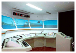
70% of the course involves hands-on practice on real ECDIS equipment connected to the fullmission bridge simulator with practical exercises performed in various dense traffic areas
Contents of the Course
- Legal requirements for the carriage of ECDIS and for the carriage of back up systems.
- Structure of ECDIS and the ENC.
- Performance standards for ECDIS (IMO Resolution 817 (19), including revised performance standards for ECDIS MSC 232 (82) adopted on 5/12/2006
- Revision of SOLAS Chapter V.
- Setting of ECDIS and back-up ECDIS
- Principal Type of Electronic Charts -

- Vectorised
- Raster
- S57 vectorised .
- Formats used for the Database S57 / S52.
- Description of the projections used for ENC.
- ECDIS as the focal component of an Integrated Navigation System.
- Raster Charts - Limitations and comparisons.
- Updating ENC and methods used -
- Automatic Loading
- Semi automatic
- Manual corrections.
- Possible errors in displayed data.
- Input sensors to ECDIS.
- Radar and ARPA interface and overlay.
- AIS targets display and information
- Passage planning and logbook function
- SAR operation
- Additional Database Information-such as tidal streams , true wind and weather overlay.
- Recording and playback of voyages performed on ECDIS.
- Dangers of over-reliance on electronic systems.
top
| | |
| | Please find below the list of documents required to get on the first day of the classroom course.- 2 passport size photographs,
- Copies of Passport, CDC, COC & INDOS No.
|
|
 |